



These will be in no particular order, but I use these frequently, so here's a guide for what they mean/are/do. It will be a living document, and If I can pin it I will, thus, it will be continually updated. These are what I know offhand. Ready? Lets go
Weather Types and Modes
Squall line/line of thunderstorms/linear modes: On a radar, these will form a literal line, with the highest precipitation rates being a thin, but long sliver typically oriented north-south. They are formed by cold fronts or troughs, and may occasionally be tilted diagonally.
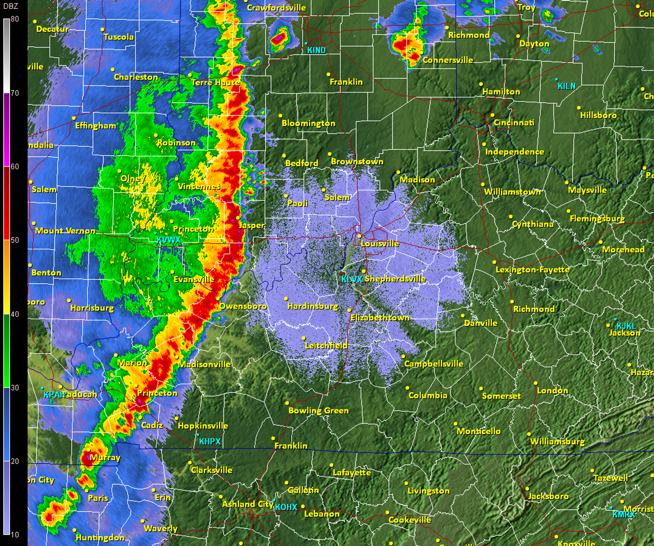
Bow Echo: A subset of a squall line, these appear as an archers bow on a radar, instead of a clean north-south, they are shaped like a backwards C. These typically form along the edges of high pressure systems.
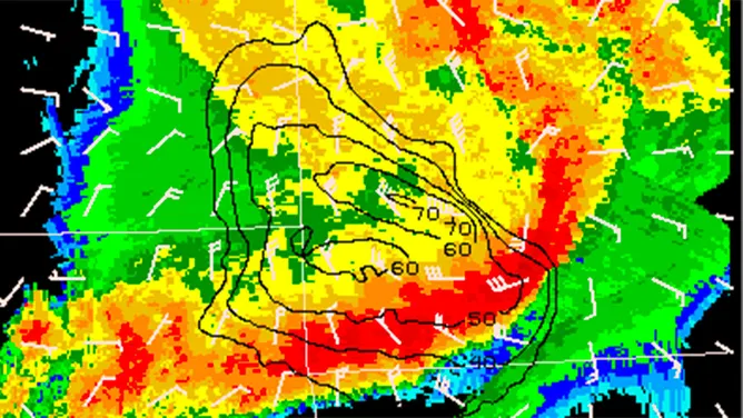
Derecho: These are long lived squalls/bow echos that require a continuous damage path of 400+ miles, a width of 60 miles, and widespread 58 mph+ (rounded up to 60 mph) wind gusts, with a concentration of 75 mph winds. They can be: Bows, Lines, or hybrid (a huge line with bows embedded inside it)
Multi-cell modes: A lone thunderstorm/cumulonimbus (cb) is a single cell, a multi cell is a cluster of these grouped together. There are multiple updrafts, and they may or may not move as a single unit. These are common when there are no or little steering currents.
Single cell modes: A single cumulonimbus.
Supercell: A cumulonimbus that is rotating due vertical wind shear (i.e wind movement changing direction with altitude), these may or may not generate tornadoes.
Tornado: A vertical column of "wind" that extends from the base of a supercell, they spin counterclockwise in the northern hemisphere and clockwise in the southern hemisphere. They are ranked by the Enhanced Fujita scale: EF0-EF5, which is derived from a combination of wind speed and damage, with damage dealt being a primary factor.
Hurricane/cyclone/typhoon: A large scale, closed low that features a ring of powerful, tall thunderstorms rotating around the low, and is usually a spiral, with the following strength categories: Non hurricane (but still requires a totally closed low): Tropical depression, tropical storm. Hurricane: category 1-5, (category 3+=major hurricane).
Atmospheric phenomena
Low Pressure: Air rises, pressure at the center of it is lower than the surrounding areas, the airmass is less "compacted", thus lower pressure, these rotate counterclockwise in the northern hemisphere, clockwise in the southern hemisphere, these bring: storms, clouds, decay of high pressure regimes, troughs and are the opposite of...
High pressure areas/anticyclone: Air sinks, pressure at the center is higher than the surrounding areas, the airmass is more "compacted", this higher pressure, these rotate clockwise in the northern hemisphere, counterclockwise in the southern hemisphere, they bring: heat waves, droughts, cloudless skies, steering for tropical cyclones. These can be evicted by
Troughs: an elongated area of mostly low air pressure, and can be formed by kinks in the jet stream, or by the lows themselves, but are not typically associated with fully closed off lows. They can either be shortwave: tight, small scale wavelength, or longwave: large scale, long, slow moving and u shaped. Deep: extending far south or shallow. They can also be
Negative tilt: better if I provide an image, see below:
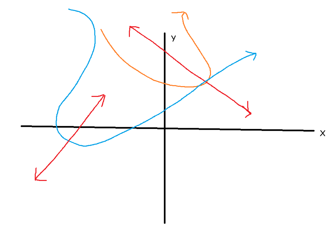
A negative tilt trough (orange) (Y=-2x+1) will produce a negative slope on a Cartesian coordinate plane if graphed from the nadir of the trough to the widest point, while a positive tilt (Y=mx+b) (blue) will be the opposite.
Negative tilt troughs are what are known as amplified, while positive troughs are known as "digging" i.e pulling south. Negative tilts are associated with severe outbreaks. Positive tilt troughs can precede them.
Frontal Systems
Cold front: This is the most disruptive of the frontal systems. Since cold air sinks, cold fronts take on a wedge shape if they try to displace an existing airmass. Due to the wedge shape, and fairly rapid movement, they can initiate significant thunderstorms. These are denoted as blue lines on frontal maps.

Warm front: The opposite of a cold front. Usually these thermal transitions are much more gentle from cold->warm, warm air rises, the transition is slower, precipitation associated with these is less heavy and more associated with stratocumulus decks and gentle precipitation. These are denoted as red lines on frontal maps.
Occluded Front: When either a warm front overtakes a cold front (rare) or a cold front overtakes a warm front (more common), these are usually associated with fronts that are closely bounded to the low itself. These are denoted as purple lines on frontal maps.
Frontogenesis: This is a process which describes the creation of fronts as a whole. Frontogenesis
is when two air masses converge, with an increasing temperature
gradient, while frontolysis is where a front decays due to two air
masses diverging (both derived from the quasi-geostrophic equations),
resulting in a weaker, or less steep temperature gradient. Let me provide images on both frontogenesis and frontoloysis: 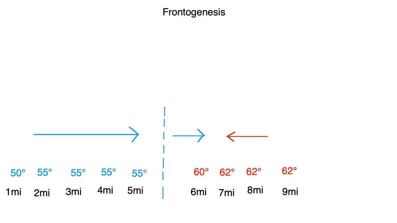
Frontolysis: This is the decay of a frontal system due to the Divergence of an airmass. 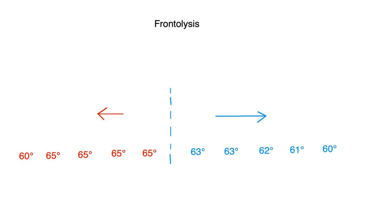
Kinematics
Air Parcel: An imaginary, and small volume of air used to measure various quantity like precipitation, temperature, etc.
Buoyancy: Upward (or sometimes downward) force on an air parcel caused by a difference in density vs the surrounding air. Highly bouyant= more aggressive vertical movement of an air parcel through the atmosphere
CAPE: This stands for Convective Available Potential Energy measured in Joules/kilogram (J/kg), this measures the amount of energy that is available in a given area that can be utilized by atmospheric processes, the higher the value, the more energy present, the more unstable the atmopshere is, the more rapid that thunderstorm development can initiate. 0 J/kg is stable, 3500 J/kg is extremely unstable. There are a few types:
SBCAPE: Surface Based CAPE- Instability in the troposphere
MUCAPE: Most Unstable CAPE- Instability of the most bouyant parcel of air
DCAPE: Downburst CAPE- Max energy of a descending parcel of air, relevant for microbursts
CINH: Convective Inhibition-measured in (-)J/Kg, represents the amount of energy required to initiate convective development, if CINH < total CAPE, storms do not form.
i.e CINH = -3500 J/kg, and CAPE is 1,250 J/kg, storms cannot initiate in that moment.
Comments
Displaying 4 of 4 comments ( View all | Add Comment )
Erah Mar
This is neat! I've always had a passing interest in meteorology and think I would have enjoyed studying it. Thank you for these terms and examples, I think I'll keep an eye on the radar more frequently!
If you have any questions, dont hesitate to dm me, I can explain weird stuff for you if you want.
by Pancreas Harvester Site Supporter;
;
Report
Site Supporter;
;
Report
Coooooool!! Thank you!
by Erah Mar; ; Report
Very Scary Fairy✨ Site Supporter
Thank you for this. I’ll have to read it six times before I’m not confused anymore, but I appreciate it nonetheless💀